Well, it's over. We're home. The house phone doesn't work. The TV picture is fuzzy. It's hot. And I just started my first load of laundry. Reality has set in.
But what a great trip we had. Joe drove the RV 10,290 miles, and probably another 5,000 in the car. We went through 7 states and 3 Canadian provinces. We toured 8 U.S. National Parks and 3 Canadian ones, and one National Monument.
We went fishing for halibut and salmon (reds). We soaked our tired bodies in 4 different hot springs. We took scenic boat rides in Waterton and Moab. We watched an awesome Air Show. We toured two knife factories and two candy factories, 2 paddle wheel boats, two fish ladders, and a dredge. We went to numerous museums and climbed on an oil derrick. We went to a wine tasting, watched clamming on the shore, watched dip-netting for salmon in the Kenai River, watched fishing boats being launched and retrieved by tractors at high and low tide. We took a plane ride to Prudhoe Bay and a van ride back, a ferry boat ride from Skagway to Haines, a dog-sled ride at the Iditarod Headquarters, and a street-car ride in Edmonton. We went to a musical show and a vaudeville show, watched a rodeo, went to a zoo, and drove through a wildlife preserve. We walked on three different types of tundra, 2 glaciers, and held glacial ice in our hands. We looked at countless totem poles, saw beautiful wood carvings, hung a sign at the Signpost Forest. We watched thousands of salmon swimming upstream to spawn, lots of eagles soaring overhead, and lots of wildlife (some in the middle of the road). We got to pan for gold several times (all without success, but it was fun wading in the creeks). And with wonderful traveling friends, who made the trip even better.
Wildlife count:
Buffalo - thousands
Caribou - hundreds
Antelope - approximately 90
Deer-154
Moose-40
Bears-32 (black and grizzly)
Elk-49
Wolves-5 (both black and gray)
Bighorn sheep-58 (including stone sheep)
Wild turkeys-4
Fox-2 (1 red, 1 gray)
Plus several grouse (some ptarmigan), beavers, snowshoe hares, some whales and sea otters, and even a herd of camels in a fenced lot.
So you can see we had a busy summer! But we wouldn't have wanted to miss a single day of it. Every day was amazing, from Day 1 to Day 137. What an EXCELLENT ADVENTURE it all was!

Sunday, October 3, 2010
Saturday, October 2, 2010
Final Day of Travel
Friday, October 1 - Today was our last day on the road! We got up pretty early and had breakfast, Joe washed the windows for a final time. A deer wandered through the edge of the campground, and a coyote was out in the meadow, so that was a nice beginning for our last day. I didn't think I would have much for our last day to blog about, but we ended up taking 37 pictures, and it was an interesting day, as all of the others have been. We left Hannigan Meadow at 8:00 a.m. (we have changed time zones again, back on Arizona time), and started down off the mountain.
 The road down from Hannigan Meadow is probably the steepest, crookedest road we have traveled this whole trip. It took us 2 1/2 hours to go the 60 miles to Morenci, usually at about 10-15 mph. The views were awesome, but it was almost a white-knuckle ride for me in some places, especially after I saw the sign that said "Vehicles over 40 foot long must turn around." Joe, of course, just plowed ahead.

 As we wound our way down through these switchback corners and hairpin curves, we came upon a few cattle right beside the road. A little more excitement than we needed.


We finally got down the mountains and the highway took us past the orenci Copper Mine, the world's largest copper producing mine. It was huge, and deep!


As we came on across Hwy 70 and then 60, I was reminded that Arizona is as beautiful as any state in this country.


We have made this drive several times, but I'm always surprised at how pretty it is. As we came through Globe, the high school was preparing for homecoming, and we saw some floats in town, then we met some more as we drove on toward Superior. We didn't stay for the parade, but they were beginning to block off the side streets.

We stopped for fuel just a mile or so from home, then we drove down our dirt road (probably the roughest road of the entire trip), and pulled into our driveway. Home sweet home. It was 104 degrees, which felt awful, but we went in, turned on the air conditioner, and waited for the house to get cool.
I intend to write one more blog, as a final wrap-up to our trip, with total mileage, wildlife count, and whatever else I come up with.
Friday, October 1, 2010
Hannigan Meadow, Arizona
Thursday, Sept. 30 - We stopped in Chinle this morning at the post office and Bashas (for donuts), then headed south. Thankfully, this highway had been resurfaced through here, because when we came through last year with Jeff and Brenda, it was really bad, and we had been dreading this section. We finally left the rocky canyon terrain and started seeing some pine trees. We had to get on I-40 for 6 miles to jog east where 191 continued on south, and we came down through St. John, Springerville and Eager. We found a nice campground in the Apache-Sitgreaves Forest in the Hannigan Meadow area, 2 miles off the road, called KP Cienaga Campground,so we set up came for the night.

 4, 5
4, 5
We had a little trouble getting into the first site we tried, and actually broke part of the fiberglass panel right behind the front tire when Joe hit a rock with it.

We moved on to another spot but couldn't get level at this one, so we moved to a third one, one with a view. There are only about 8 sites here.


It was nice and cool up here, elevation 8970. Joe said he wasn't camping below 8800 on our last night out, so that met his criteria. We hoped to see some elk wander through this meadow, but none showed up. There are 4 other campers in here, in tents; I think one group is hunters. After a frustrating time getting settled in, Joe finally got to sit down and enjoy the scenery and temperature.

We drove 223 miles today, and probably have 250 to go tomorrow to get us home. Fortunately, we didn't have to go home by way of Wisconsin, so we should be home on October 1, Day 137 of this trip. Both grandkids have games on Saturday, and I intend to be there.
Our final route takes us down 191 to Safford, then across 70 to Globe, then 60 HOME.

 4, 5
4, 5We had a little trouble getting into the first site we tried, and actually broke part of the fiberglass panel right behind the front tire when Joe hit a rock with it.

We moved on to another spot but couldn't get level at this one, so we moved to a third one, one with a view. There are only about 8 sites here.


It was nice and cool up here, elevation 8970. Joe said he wasn't camping below 8800 on our last night out, so that met his criteria. We hoped to see some elk wander through this meadow, but none showed up. There are 4 other campers in here, in tents; I think one group is hunters. After a frustrating time getting settled in, Joe finally got to sit down and enjoy the scenery and temperature.

We drove 223 miles today, and probably have 250 to go tomorrow to get us home. Fortunately, we didn't have to go home by way of Wisconsin, so we should be home on October 1, Day 137 of this trip. Both grandkids have games on Saturday, and I intend to be there.
Our final route takes us down 191 to Safford, then across 70 to Globe, then 60 HOME.
Canyon de Chelly
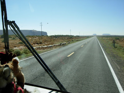
Wednesday, Sept. 30 - We are back in Arizona! We left Monticello this morning with about 70 miles to go to the state line, and we hit Arizona about 11:00 a.m. The highway through Chinle (Hwy 191) is open range, which we remembered from our trip to Colorado with Jeff and Brenda last summer, and you have to really watch out for livestock on the road. We came upon a small group of horses right by the road. We don't think they were wild, because one had a halter on, so we assume they are just left to graze on this open range.

As we got to Chinle, we had to stop for a flock (or herd) of goats that were being herded across the road. There were 2 dogs leading them through a hole in the fence, and a goatherder pushing them.
 3
3
This is a pretty drive, with some rock formations (we saw one arch) and beautiful scenery in the distance.


We got to Canyon de Chelly, which is a National Monument, but is unlike and other national park in that the canyons are within the Navajo Nation and include a residential community, and not all areas are open to the general public. There is a nice campground here inside the park, and it is free camping.


We got set up in the campground, then went to the Visitor Center. For those of you who have questions about how to see this National Monument, there are a few options. You can drive the North Rim (34 miles roundtrip) and South Rim (37 miles roundtrip) roads in your own vehicle, by yourself, and there is one hiking trail you are allowed to take. The road is good, so that is not a problem. Or you can hire a guide to ride with you ($15 per hour), but still drive your own vehicle if it is a 4-wheel drive. This tour will take you to the floor of the canyon. You can also take jeep tours that take you to the bottom of the canyon. We saw one of the jeeps, from the lodge here, and it was open top, probably seated 15 or so. You can also tour the canyon on horseback. We just did the self-guided tour of the South Rim. There are several look-out points along both rim drives. This rock formation, at the end of the South Rim Drive, is called "Spider Rock," and is an 800-ft. sandstone spire that rises from the canyon floor.

From different viewpoints, you can see the canyon floor, and there are some houses down there. You can also see some Anasazi ruins under the overhangs of the cliff walls.


This is a beautiful canyon, with some spectacular views of rock formations, but after looking at rocks for 3 days in Arches, Canyonlands, and the scenic byway to Moab, it was a bit anti-climatic for us. We opted not to drive the second rim road, but instead, drove into Chinle to check out the town (which didn't take long). We did come upon a pick-up truck herding 4 horses across the road.

We stopped at the Bashas grocery store (they don't sell any beer here) and then went to Church's Chicken for dinner. It was hot in the restaurant, so we took it back to the campground and ate at our picnic table. We are finally getting closer to home!

As we got to Chinle, we had to stop for a flock (or herd) of goats that were being herded across the road. There were 2 dogs leading them through a hole in the fence, and a goatherder pushing them.
 3
3This is a pretty drive, with some rock formations (we saw one arch) and beautiful scenery in the distance.


We got to Canyon de Chelly, which is a National Monument, but is unlike and other national park in that the canyons are within the Navajo Nation and include a residential community, and not all areas are open to the general public. There is a nice campground here inside the park, and it is free camping.


We got set up in the campground, then went to the Visitor Center. For those of you who have questions about how to see this National Monument, there are a few options. You can drive the North Rim (34 miles roundtrip) and South Rim (37 miles roundtrip) roads in your own vehicle, by yourself, and there is one hiking trail you are allowed to take. The road is good, so that is not a problem. Or you can hire a guide to ride with you ($15 per hour), but still drive your own vehicle if it is a 4-wheel drive. This tour will take you to the floor of the canyon. You can also take jeep tours that take you to the bottom of the canyon. We saw one of the jeeps, from the lodge here, and it was open top, probably seated 15 or so. You can also tour the canyon on horseback. We just did the self-guided tour of the South Rim. There are several look-out points along both rim drives. This rock formation, at the end of the South Rim Drive, is called "Spider Rock," and is an 800-ft. sandstone spire that rises from the canyon floor.

From different viewpoints, you can see the canyon floor, and there are some houses down there. You can also see some Anasazi ruins under the overhangs of the cliff walls.


This is a beautiful canyon, with some spectacular views of rock formations, but after looking at rocks for 3 days in Arches, Canyonlands, and the scenic byway to Moab, it was a bit anti-climatic for us. We opted not to drive the second rim road, but instead, drove into Chinle to check out the town (which didn't take long). We did come upon a pick-up truck herding 4 horses across the road.

We stopped at the Bashas grocery store (they don't sell any beer here) and then went to Church's Chicken for dinner. It was hot in the restaurant, so we took it back to the campground and ate at our picnic table. We are finally getting closer to home!
Tuesday, September 28, 2010
Canyonlands National Park - Needles
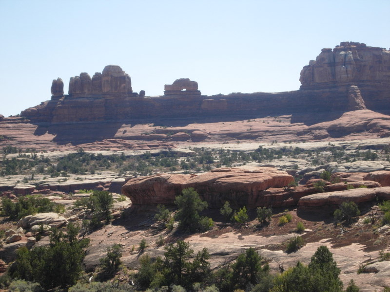
Tuesday, Sept. 28 - We left Moab this morning and headed to the other section of the Canyonlands National Park, the Needles section. We passed one arch on Highway 191.
 We turned off onto Hwy 211 and drove partway on this road toward the park. We stopped at the Newspaper Rock, which has petroglyphs and pictographs that go way back, but they have no way of dating the pictures so they really don't kno how old they are. Petroglyphs are pictures that are "pecked into" the rocks; pictographs are painted on the rocks. Often they are both.

 The drive into the park was 19 miles and it was very scenic.

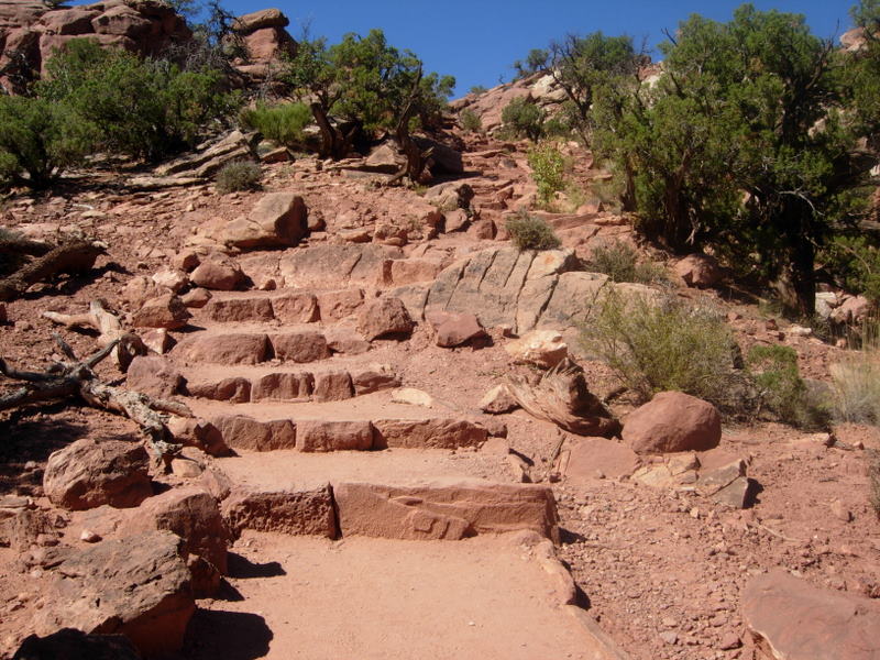
 We found a big parking lot next to a rock-climbing area, so we unhooked the car and left the RV there. We had considered trying to camp in this park but decided we should check it out before driving all the way in. We drove back to one campground just outside the park, but it was in the sun and just dirt parking areas. We stopped at the Visitor Center and had a picnic lunch outside there, then off we went. Our first "hike" (and only one today) was back to the ruins from and old storage cache where corn, flaxseed and other seeds were stored. This was a short hike, but the trail was marked on the rocks with cairns.


There were a few arches in this park. Here is one named "Wooden Shoe Arch."
 We drove to the end of this drive, then came through the campground on the way out. It was pretty unique, with some campsites right next to huge rocks, but there were very few that we would have fit in. We took a drive down a dirt road to the Elephant Hill trailhead, but we didn't make that hike. We could see the "Needles" pretty well on this drive though.


There was one other campground just outside the park, Hamburger Rock. We drove around it too but decided it was not for us. We then headed back to reclaim the RV and leave the park. We drove on to the next town, Monticello, Utah, and found an RV park for the night. The price of gas here was $3.29. As I was paying for our fill-up ($173.09), the attendant told me she thought the price of gas in Arizona is $2.49! Well, I hope it is, but maybe we should only have put in a half tank if that is the case. We'll see tomorrow, we should make Arizona tomorrow I think. We are planning on going to Chinle and seeing if we can get a tour of Canyon de Chelly.


There were a few arches in this park. Here is one named "Wooden Shoe Arch."


There was one other campground just outside the park, Hamburger Rock. We drove around it too but decided it was not for us. We then headed back to reclaim the RV and leave the park. We drove on to the next town, Monticello, Utah, and found an RV park for the night. The price of gas here was $3.29. As I was paying for our fill-up ($173.09), the attendant told me she thought the price of gas in Arizona is $2.49! Well, I hope it is, but maybe we should only have put in a half tank if that is the case. We'll see tomorrow, we should make Arizona tomorrow I think. We are planning on going to Chinle and seeing if we can get a tour of Canyon de Chelly.
Canyonlands National Park
Monday, Sept. 27. Happy Birthday, Dixie.
This morning we headed out to Canyonlands National Park, to the Island in the Sky section, the entrance is just a few miles north of Moab. The park is actually about 23 miles back this highway. Our first stop was at the Monitor and Merrimac buttes.

The layers of rock are fascinating. It looks like just one sheet after another was layered on top of the next.

We stopped at the Visitor Center and listened to a brief talk about the history of this region by a real cute park ranger gal. We stopped at the Shafer Canyon Overlook, and you could see the road through this canyon that the ranchers used to move cattle. Joe, of course, wants to drive this very narrow, steep, windy, switchback, no-guard-rail road, but I think I have got him talked out of it this trip, because the tires on the Explorer are getting pretty thin and this road is no place for a flat tire.


I volunteered his sister, Dixie, to accompany him on it sometime, especially since today is her birthday, and she just "loves" these kinds of trips with her adoring brother. We'll see if that happens sometime in the future.
There are a few arches in this park too, and this Mesa Arch has a beautiful view through its window. This was a short hike, about a half-mile, but it is warming up. Of course the picture is really enhanced with me in the window!
 Our next hike was more strenuous, to the Upheaval Dome. The path was marked with cairns along the way (we just learned that's what these little stacks of rock are called).
 At one spot, Joe said, "they put this one right in the middle of the trail" and he stepped right over it. Me, being the expert hiker that I am, saw that the real trail turned right here and he was actually going off-trail, so I quickly straightened him out. This was about a mile hike and it was a little steep in places (although it had good steps) and it was hot out by now. This gave us our aerobic exercise for the day.
 At the Green River Overlook, we could see the Green River windy its way through the canyons.
 At the end of the road was the Grand View Point, and it was grand. Beyond this point is the confluence of the Colorado and Green Rivers but the water was hidden from view by the deep canyons. But the view was terrific.

 Right in the middle of this last picture is a formation called a "totem," so Mazie, this one is for you. There are spires behind it, but this one stands alone.
 Our last event of the day was a "Lights and Sound" boat trip up the Colorado River, preceded by a cowboy dinner. The river was laying like glass and you hardly realized you were even on a boat. The boat was set up like a barge with rows of chairs, and it was completely open. Our narrator was an old cowboy who pointed out rock formations that resembled faces or animals, and he told us some of the history of the region. Once it got dark, the boat was turned around and there was a truck on the highway along the river that lit up the rock walls very dramatically and a tape played with the history of the formation of the canyon. The sky was dotted with flickering stars and we could see the Milky Way. It was a nice presentation and a nice end to this part of our trip.
This morning we headed out to Canyonlands National Park, to the Island in the Sky section, the entrance is just a few miles north of Moab. The park is actually about 23 miles back this highway. Our first stop was at the Monitor and Merrimac buttes.

The layers of rock are fascinating. It looks like just one sheet after another was layered on top of the next.

We stopped at the Visitor Center and listened to a brief talk about the history of this region by a real cute park ranger gal. We stopped at the Shafer Canyon Overlook, and you could see the road through this canyon that the ranchers used to move cattle. Joe, of course, wants to drive this very narrow, steep, windy, switchback, no-guard-rail road, but I think I have got him talked out of it this trip, because the tires on the Explorer are getting pretty thin and this road is no place for a flat tire.


I volunteered his sister, Dixie, to accompany him on it sometime, especially since today is her birthday, and she just "loves" these kinds of trips with her adoring brother. We'll see if that happens sometime in the future.
There are a few arches in this park too, and this Mesa Arch has a beautiful view through its window. This was a short hike, about a half-mile, but it is warming up. Of course the picture is really enhanced with me in the window!


 At the end of the road was the Grand View Point, and it was grand. Beyond this point is the confluence of the Colorado and Green Rivers but the water was hidden from view by the deep canyons. But the view was terrific.


Subscribe to:
Posts (Atom)