Tuesday, September 28, 2010

Canyonlands National Park - Needles

Tuesday, Sept. 28 - We left Moab this morning and headed to the other section of the Canyonlands National Park, the Needles section.  We passed one arch on Highway 191.
We turned off onto Hwy 211 and drove partway on this road toward the park.  We stopped at the Newspaper Rock, which has petroglyphs and pictographs that go way back, but they have no way of dating the pictures so they really don't kno how old they are.  Petroglyphs are pictures that are "pecked into" the rocks; pictographs are painted on the rocks.  Often they are both.
The drive into the park was 19 miles and it was very scenic.
We found a big parking lot next to a rock-climbing area, so we unhooked the car and left the RV there.  We had considered trying to camp in this park but decided we should check it out before driving all the way in.  We drove back to one campground just outside the park, but it was in the sun and just dirt parking areas.  We stopped at the Visitor Center and had a picnic lunch outside there, then off we went.  Our first "hike" (and only one today) was back to the ruins from and old storage cache where corn, flaxseed and other seeds were stored.  This was a short hike, but the trail was marked on the rocks with cairns.


 There were a few arches in this park.  Here is one named "Wooden Shoe Arch."
We drove to the end of this drive, then came through the campground on the way out.  It was pretty unique, with some campsites right next to huge rocks, but there were very few that we would have fit in.  We took a drive down a dirt road to the Elephant Hill trailhead, but we didn't make that hike.  We could see the "Needles" pretty well on this drive though.

 There was one other campground just outside the park, Hamburger Rock.  We drove around it too but decided it was not for us.  We then headed back to reclaim the RV and leave the park.  We drove on to the next town, Monticello, Utah, and found an RV park for the night.  The price of gas here was $3.29.  As I was paying for our fill-up ($173.09), the attendant told me she thought the price of gas in Arizona is $2.49!  Well, I hope it is, but maybe we should only have put in a half tank if that is the case.  We'll see tomorrow, we should make Arizona tomorrow I think.  We are planning on going to Chinle and seeing if we can get a tour of Canyon de Chelly. 

Canyonlands National Park

Monday, Sept. 27.  Happy Birthday, Dixie.

This morning we headed out to Canyonlands National Park, to the Island in the Sky section, the entrance is just a few miles north of Moab.  The park is actually about 23 miles back this highway.  Our first stop was at the Monitor and Merrimac buttes.


 The layers of rock are fascinating.  It looks like just one sheet after another was layered on top of the next.

We stopped at the Visitor Center and listened to a brief talk about the history of this region by a real cute park ranger gal.  We stopped at the Shafer Canyon Overlook, and you could see the road through this canyon that the ranchers used to move cattle.  Joe, of course, wants to drive this very narrow, steep, windy, switchback, no-guard-rail road, but I think I have got him talked out of it this trip, because the tires on the Explorer are getting pretty thin and this road is no place for a flat tire. 

 I volunteered his sister, Dixie, to accompany him on it sometime, especially since today is her birthday, and she just "loves" these kinds of trips  with her adoring brother.  We'll see if that happens sometime in the future.
There are a few arches in this park too, and this Mesa Arch has a beautiful view through its window.  This was a short hike, about a half-mile, but it is warming up.  Of course the picture is really enhanced with me in the window!
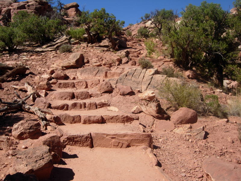
Our next hike was more strenuous, to the Upheaval Dome.  The path was marked with cairns along the way (we just learned that's what these little stacks of rock are called).
At one spot, Joe said, "they put this one right in the middle of the trail" and he stepped right over it. Me, being the expert hiker that I am, saw that the real trail turned right here and he was actually going off-trail, so I quickly straightened him out.  This was about a mile hike and it was a little steep in places (although it had good steps) and it was hot out by now.  This gave us our aerobic exercise for the day.
 At the Green  River Overlook, we could see the Green River windy its way through the canyons.
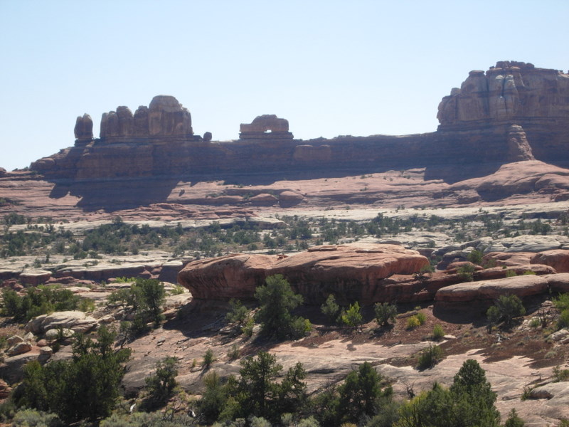
At the end of the road was the Grand View Point, and it was grand.  Beyond this point is the confluence of the Colorado and Green Rivers but the water was hidden from view by the deep canyons.  But the view was terrific.
Right in the middle of this last picture is a formation called a "totem," so Mazie, this one is for you.  There are spires behind it, but this one stands alone.

Our last event of the day was a "Lights and Sound" boat trip up the Colorado River, preceded by a cowboy dinner.  The river was laying like glass and you hardly realized you were even on a boat.  The boat was set up like a barge with rows of chairs, and it was completely open.  Our narrator was an old cowboy who pointed out rock formations that resembled faces or animals, and he told us some of the history of the region.  Once it got dark, the boat was turned around and there was a truck on the highway along the river that lit up the rock walls very dramatically and a tape played with the history of the formation of the canyon.  The sky was dotted with flickering stars and we could see the Milky Way.  It was a nice presentation and a nice end to this part of our trip.

Sunday, September 26, 2010

Arches National Park

Sunday, Sept. 26 - This morning we grabbed a breakfast sandwich and a bag of ice at McDonalds, then headed to Arches National Park, just a couple miles out of town.  We stopped at the Visitors Center first, then headed up the hill.  There was an amazing amount of traffic here in this park today, and it was supposed to hit 89 degrees.  We took lots of pictures, and made one hike in the Windows section to get a close-up look at those arches.  There are supposed to be 2000 arches in the park, but we probably only saw 10 or 12.  There are lots of hikes in the park, and some secondary roads to arches that we did not take.  The beginning of the drive is full of rock formations, then they get a little more scattered, with valleys in between.  The campground is at the end of the drive, and it was full.  We did drive through it to see if we could have fit in, and there were a few spots that were big enough, but many were too small for our rig.  Here's some of the rock formations.

This next one was called "Three Gossips."
The one above was called "Balanced Rock."  The top rock is estimated to weigh 3500 tons.  We walked completely around this and couldn't imagine what made it stay up there.  There were many other balanced rocks in the park, like the one below.


 This was called the Turret Arch.


This is the hike we took.  These are the North and South Windows.  We started out on the main trail, but when we went behind these arches, we ended up on a primitive trail.  We were pretty warm by the time we got back to the parking lot.


Here's Joe on the climb to Turret Arch, and then when he gets to the top of the path.


These formations were called the "Fiery Furnace" which is supposed to be really beautiful at sunset.


It was a pretty impressive drive, but we thought the scenic highway coming into Moab yesterday was even more impressive.  We stopped on our way back through town and made reservations to take a boat ride tomorrow night on the Colorado River, so that should be entertaining.  In addition to the t-shirt that Joe needs that says "authorized person," he thinks he also needs a cap that says "service," since there are always lots of "service roads," that he is not allowed on.  Maybe he just needs a badge.

Saturday, September 25, 2010

From Colorado to Moab, Utah

Saturday, Sept. 25 - We left our nice little campground in Colorado this morning and headed back into Utah, to Moab.  We picked up I-70 at Loma and got off on some little scenic road that connected with Hwy 128.  We kept leapfrogging with a group of bicyclists, and I finally told Joe we needed to speed up a little so they didn't pass us again (they actually only passed us when we were pulled off, but they certainly were in our rear-view mirror for a long time).  This highway parallels the Colorado River all the way into Moab, and it is like driving at the bottom of the Grand Canyon.  There were hoodoos, red, sheer cliff walls, a ranch (Sorrel River Ranch and Restaurant) with a beautiful green pasture against the backdrop of the red cliffs, a winery and grape arbor, and just beautiful scenery.  I'm just going to post a few of the 69 pictures we took, which include me washing a "Brenda" rock, and the two of us with this beautiful background.  Joe and Cathy -- put this highway on your list of "must" drives.  This was awesome.