Today is a travel day again. And apparently I just deleted today's pictures in my downloading process, so this should be a short blog. We were on the road about 9:35, dumped, fueled and at the border by 10:00, and across the border by 10:05 (after paying $12), and through Customs by 10:10. After all our efforts to come across legal (or whatever the right word is), the only questions we were asked were: where are we going, and do we have any firearms. I should have offered the Customs guard one of my 10 hard-boiled eggs!
But as we came across the bridge, one of the big freighters was going through the locks, so I'm sorry I didn't get those pictures posted. I don't know if it was one of the 1,000-feet longs ones, but it looked pretty substantial to me.
Our one stop today was at the Canadian Bushplane Heritage Centre, which was right on the river bank and we could see it from our campground last night. They had a nice selection of planes, varying sizes, and some of the planes we could walk into. They also showed two awesome movies with special effects. The second movie was about fighting forest fires with these planes, it was 3-D, and it was really interesting and educational. With our Arizona forest fire history, we all found it to be very enlightening.
We left there about noon and drove until 4:00, to Sudbury, Ontario, 198 miles. We fueled in the U.S. right before we crossed the bridge for $2.789. We have seen gas prices here in Sudbury for $1.219 per liter, so we think that figures out to be $4.60 per gallon in Canadian dollars, which we think converts to about $3.22 U.S. dollars, maybe. Not sure about that, though. We will fuel tomorrow, but we probably won't have any more of a clue what we are paying until the credit card bill comes in.
We had trouble again with the voltage at the RV park. So many of these parks in this part of the country are old, the wiring is old, and apparently doesn't carry enough voltage to run our A/C. We moved to a different site, and it is a little better, but not great. Fortunately, we had a little rain storm blow through which cooled everything off, so I think we will get by tonight without running the A/C.
Since we didn't want to use the convection oven or heat up the RVwith the stove, we drove into Sudbury to look the town over and find some dinner. We ended up at a fancy pizza place, which was pretty good, but a little expensive, and many things on the menu were foreign to us hicks. But we had dinner, bought some eggs, and got back to camp for the night (so I could delete my photos!). We are making forward progress now, though. Should be meet back up with the Brundiges on Friday if all goes well.

Wednesday, July 29, 2015
Tuesday, July 28, 2015
Arriving Sault Ste. Marie, Michigan (7/28/2015)
I thought today was going to be a pretty easy, short day, but it turned out to be one of those days that just doesn't quit. I walked down to say hi to Mazie this morning, and we ran into the "pie guy" from yesterday. Lo and behold, he was staying in our campground. He asked how the pie was, otherwise we would not have recognized him. But he recognized us, go figure!
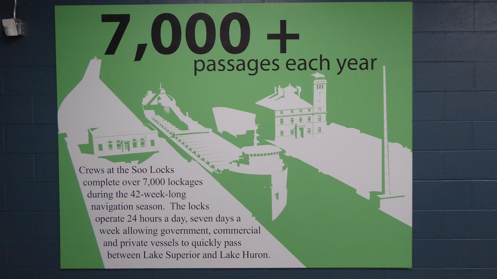
We were on the road by 9:20, and only had 72 miles to go. Didn't see anything extraordinary on our drive into Sault Ste. Marie, and arrived at our campground about 11:00. We had to move to a different campsite because the voltage was too low and kept kicking off the electricity, which shut everything down, including the A/C, because of our surge protector. And it was hot here today, high 90s, so we definitely needed the A/C. But we finally got situated ok, with a view of St. Mary's River, where the ships go between Lake Superior and Lake Huron.
We had a "to do" list for this town, so off we went, stopping for lunch, then on to Walmart to: get Joe's glasses fixed (one of the nose pieces came off), and pick up a few groceries, keeping in mind that we will be crossing the border probably tomorrow so we didn't buy any fruit. Well, first problem, Joe forgot his glasses. Good thing we had put Walmart in the GPS because he would be coming back. I asked one of the clerks about what food we couldn't take across the border, and he said eggs and poultry was what they were not allowing into Canada because of the avian flu, so I gave one of the clerks my package of frozen chicken and checked out. I have about 15 eggs in my refrigerator, so I guess I will be boiling eggs tonight.
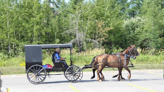
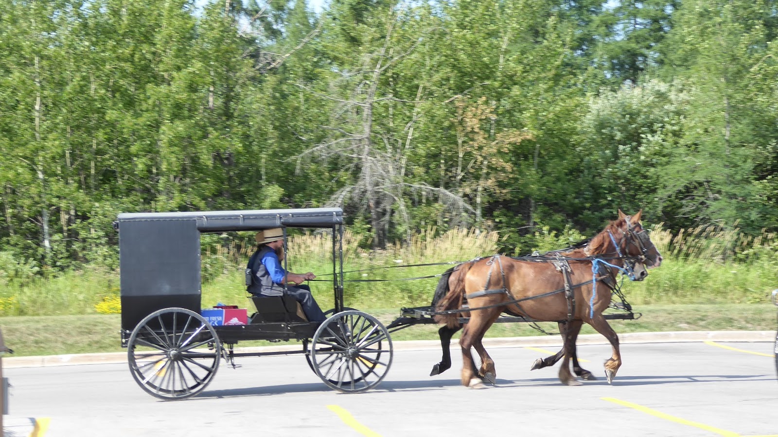
We went back to camp, and I went up to do laundry while Joe went back to Walmart with his glasses, which they fixed for $1.98. He drove around town, checking out viewing places for the locks here. While he was gone, I called Canadian Customs to find out what we were not allowed to bring across. Well, they were right about the eggs and poultry, but we could bring fruit in. So when Joe got back from Walmart, Mazie and I got back in the car with him and off we went again, to a farmer's market we had seen on the way to Walmart. They didn't have much, so we ended up back at Walmart (Joe for the 3rd time). As we were leaving this time, we saw an Amish family arrive in their horse and buggy.
On the way home this time, I noticed a Verizon store and I mentioned it but he didn't hear me. I'll get back to that later. So we dropped Mazie off at the campground, then we went for a drive along the St. Mary's river, to see if we could see any ships. We did see one ship pass the campground, but it had already come through the locks, heading east or south, who knows which direction anything is anymore?

There is an infestation of may flies here, they about drive us crazy. And it is very warm and humid, although it is supposed to rain tomorrow. On our River drive, we saw a tugboat, and watched a ferry loaded with cars going to to Sugar Island.


Then Joe wanted to show me where we could view the ships passing through the locks. As we got near there, he mentioned that we needed a Verizon store. I told him I had seen one, and mentioned it, but he hadn't heard me. It was down by Walmart. So off we went again, just short of Walmart this time. We spent almost an hour there, changing our Canada plan and trying to get the military discount he is entitled to, but I had left his DD214 back at the RV, so we didn't get that accomplished. We closed that store (7:00 p.m.), stopped across the street at McDonalds, then we headed for the viewing platform at the locks. We lucked out here. We sat down in the viewing stands to eat, and only had to wait about 15 minutes for a ship to come through! That was cool. It was 655 ft. long and 77 inches wide. The lock it passed through, the Poe Lock, is the widest one at 110 ft., but the other ones in use are only 80 feet wide so that ship had to use the Poe Lock.


 You can see how much higher the letters on the side of the ship are as the lock fills.
Another really cool thing was the railroad bridge just down from the locks. It is one of those "elevator" bridges, and we watched a train cross while the ship was in the lock. Actually, I think the ship had to wait for the train to get off the bridge (the train had stopped for a few minutes) before they let the ship move on. So we got to watch the bridge raise like an elevator.


 And here is the ship passing under that elevated bridge.


We stayed there until about 8:30, then walked in the Visitor Center and learned that we can call a number and get an estimate for when the ships will be coming through. Too bad we didn't know that earlier.


Then we walked across the street into some of the downtown gift shops. We got back to the RV about 9:15, still wound up from our busy day. We can see the river out the front window of the RV, so as I am trying to get the Verizon form filled out on the computer, I see lights moving out on the river and thought it was a ship, so I put my shoes back on and ran down to the river's edge to see. It was just a tugboat and a barge, but the lights are so pretty across the river that I finally decided I had to take some pictures. So I ran back to the RV, put the battery and picture chip back in the camera, and came back down to take some pictures.


 Then about 15 minutes later, I saw lights moving again, and this time it was a ship, so back down to the river for more pictures.


I spent about an hour on the Verizon website but I think I finally got my form submitted. We remembered the eggs about 11:30. I decided to let them wait until morning because I always have time before Joe gets up. But he decided we should boil them tonight, so he got them started, then went to bed. They should be done at midnight. And I just saw another ship go by. But I have my nightgown on now, so I stayed inside.
So the Canada Verizon plan we are now on is: 500 minutes for me, 500 outgoing texts for me, unlimited incoming texts for me, 1 gig of data -- and we are turning Joe's phone off until we get back to the U.S., which will probably be 3-4 weeks. We put it all on my phone, so if anyone needs to reach us, call or text me. I won't be able to post my blog with this limited amount of data, so blogging will be sketchy for the duration, I'll have to depend on WiFi, and that is not very dependable at the campgrounds -- some of them have it but it's not strong enough to carry the load or something in the evenings. Usually I can get on early in the mornings, but not always; but it apparently has too many people during the evening and we don't ever seem to be able to get it to connect.
Well, it's 12:05 a.m. The eggs are done. It is time to call it a day!
We were on the road by 9:20, and only had 72 miles to go. Didn't see anything extraordinary on our drive into Sault Ste. Marie, and arrived at our campground about 11:00. We had to move to a different campsite because the voltage was too low and kept kicking off the electricity, which shut everything down, including the A/C, because of our surge protector. And it was hot here today, high 90s, so we definitely needed the A/C. But we finally got situated ok, with a view of St. Mary's River, where the ships go between Lake Superior and Lake Huron.
We had a "to do" list for this town, so off we went, stopping for lunch, then on to Walmart to: get Joe's glasses fixed (one of the nose pieces came off), and pick up a few groceries, keeping in mind that we will be crossing the border probably tomorrow so we didn't buy any fruit. Well, first problem, Joe forgot his glasses. Good thing we had put Walmart in the GPS because he would be coming back. I asked one of the clerks about what food we couldn't take across the border, and he said eggs and poultry was what they were not allowing into Canada because of the avian flu, so I gave one of the clerks my package of frozen chicken and checked out. I have about 15 eggs in my refrigerator, so I guess I will be boiling eggs tonight.
We went back to camp, and I went up to do laundry while Joe went back to Walmart with his glasses, which they fixed for $1.98. He drove around town, checking out viewing places for the locks here. While he was gone, I called Canadian Customs to find out what we were not allowed to bring across. Well, they were right about the eggs and poultry, but we could bring fruit in. So when Joe got back from Walmart, Mazie and I got back in the car with him and off we went again, to a farmer's market we had seen on the way to Walmart. They didn't have much, so we ended up back at Walmart (Joe for the 3rd time). As we were leaving this time, we saw an Amish family arrive in their horse and buggy.
On the way home this time, I noticed a Verizon store and I mentioned it but he didn't hear me. I'll get back to that later. So we dropped Mazie off at the campground, then we went for a drive along the St. Mary's river, to see if we could see any ships. We did see one ship pass the campground, but it had already come through the locks, heading east or south, who knows which direction anything is anymore?

There is an infestation of may flies here, they about drive us crazy. And it is very warm and humid, although it is supposed to rain tomorrow. On our River drive, we saw a tugboat, and watched a ferry loaded with cars going to to Sugar Island.


Then Joe wanted to show me where we could view the ships passing through the locks. As we got near there, he mentioned that we needed a Verizon store. I told him I had seen one, and mentioned it, but he hadn't heard me. It was down by Walmart. So off we went again, just short of Walmart this time. We spent almost an hour there, changing our Canada plan and trying to get the military discount he is entitled to, but I had left his DD214 back at the RV, so we didn't get that accomplished. We closed that store (7:00 p.m.), stopped across the street at McDonalds, then we headed for the viewing platform at the locks. We lucked out here. We sat down in the viewing stands to eat, and only had to wait about 15 minutes for a ship to come through! That was cool. It was 655 ft. long and 77 inches wide. The lock it passed through, the Poe Lock, is the widest one at 110 ft., but the other ones in use are only 80 feet wide so that ship had to use the Poe Lock.


Another really cool thing was the railroad bridge just down from the locks. It is one of those "elevator" bridges, and we watched a train cross while the ship was in the lock. Actually, I think the ship had to wait for the train to get off the bridge (the train had stopped for a few minutes) before they let the ship move on. So we got to watch the bridge raise like an elevator.


We stayed there until about 8:30, then walked in the Visitor Center and learned that we can call a number and get an estimate for when the ships will be coming through. Too bad we didn't know that earlier.

 |
| The Four Lock Channels |

Then we walked across the street into some of the downtown gift shops. We got back to the RV about 9:15, still wound up from our busy day. We can see the river out the front window of the RV, so as I am trying to get the Verizon form filled out on the computer, I see lights moving out on the river and thought it was a ship, so I put my shoes back on and ran down to the river's edge to see. It was just a tugboat and a barge, but the lights are so pretty across the river that I finally decided I had to take some pictures. So I ran back to the RV, put the battery and picture chip back in the camera, and came back down to take some pictures.


I spent about an hour on the Verizon website but I think I finally got my form submitted. We remembered the eggs about 11:30. I decided to let them wait until morning because I always have time before Joe gets up. But he decided we should boil them tonight, so he got them started, then went to bed. They should be done at midnight. And I just saw another ship go by. But I have my nightgown on now, so I stayed inside.
So the Canada Verizon plan we are now on is: 500 minutes for me, 500 outgoing texts for me, unlimited incoming texts for me, 1 gig of data -- and we are turning Joe's phone off until we get back to the U.S., which will probably be 3-4 weeks. We put it all on my phone, so if anyone needs to reach us, call or text me. I won't be able to post my blog with this limited amount of data, so blogging will be sketchy for the duration, I'll have to depend on WiFi, and that is not very dependable at the campgrounds -- some of them have it but it's not strong enough to carry the load or something in the evenings. Usually I can get on early in the mornings, but not always; but it apparently has too many people during the evening and we don't ever seem to be able to get it to connect.
Well, it's 12:05 a.m. The eggs are done. It is time to call it a day!
Monday, July 27, 2015
Tahquamenon Falls, Shipwreck Museum (7/27/2015)
The
Upper Tahquamenon Falls is the second largest waterfall east of the
Mississippi River. - See more at:
http://www.michigansparadise.com/tahquamenom-falls/#sthash.4hE5wxHL.dpuf
It was 66 when I got up this morning, a little brisk here in the U.P. We set out to our first attraction, the Upper Tahquamenon. Tahquamenon rhymes with phenomenon, I learned today. This is the second largest waterfall east of the Mississippi River. "In the heart of the second largest
Michigan state park, the 90 mile long Tahquamenon River rushes over a 50 foot
drop at the magnificent Upper Tahquamenon Falls. Four miles downstream, a
series of five smaller drops make up the majestic Lower Tahquamenon Falls,
carrying the river farther downstream before emptying into Lake Superior at the
rivermouth." I assume this is second to Niagara Falls, and it is a distant second. But we did check it out, walked the 96 steps down to the top of the falls, then walked those 96 steps back up! We saved the Lower Falls until later in the day.


Joe climbed up on the fence to get this photo.

And there's always steps to waterfalls.

From there we headed up to Paradise, on the way to the Shipwreck Museum. In the little village of Paradise, Joe stopped at a convenience store looking for his soda. They didn't have any, so we drove across the street to a bakery/restaurant, on the hunt for donuts. Mazie is still looking to match that donut we had on Mackinac Island.

We got seated and ordered our pastries. A local couple came in and sat down at the next table. They ordered blueberry pie. This area is famous for wild blueberries, and they raved about them, said they were picking them now (we didn't see any pickers in our travels today). While Mazie and I shopped the gift shop, Joe must have sucked up to the pie eaters because when they got ready to leave, they bought a whole blueberry pie and gave it to Joe. There is still a debate about whether or not he is going to share it with the rest of us.

We didn't buy anything in the gift shop, but Joe did find something he needed.
And then it was off to Whitefish Point to the Shipwreck Museum. David offered to hold the pie, but we elected to put it in the back of the car instead. Didn't trust him.
The Shipwreck Museum was part of a complex of several buildings: the Museum, a theatre, Lifeboat Station, Gift Shop with Fudge, Overnight Lodge, Light Station (lighthouse), and another gift shop dedicated to bird watchers. All of the exhibits in the museum were very interesting, as was the video and the Lifeboat Station. Although we have seen a couple of lighthouses already, this was a nice one, fully furnished with period furniture.


Joe is always interested in the prisms in lighthouses and was disappointed that one of the ones we toured earler no longer had one. But today he got to check out a couple.


It was a great beach, and with the exception of a couple kayakers out in the water, we had it to ourselves. So, of course, Mazie and I had to pick up a few rocks.


We finally left this great beach and headed back to camp. After our dinner (Dave and Mazie ate later), we picked Mazie up and went to check out the Lower Tahquamenon Falls. This was a totally different adventure. People were swimming in them, boating across, wading, splashing with their dogs.

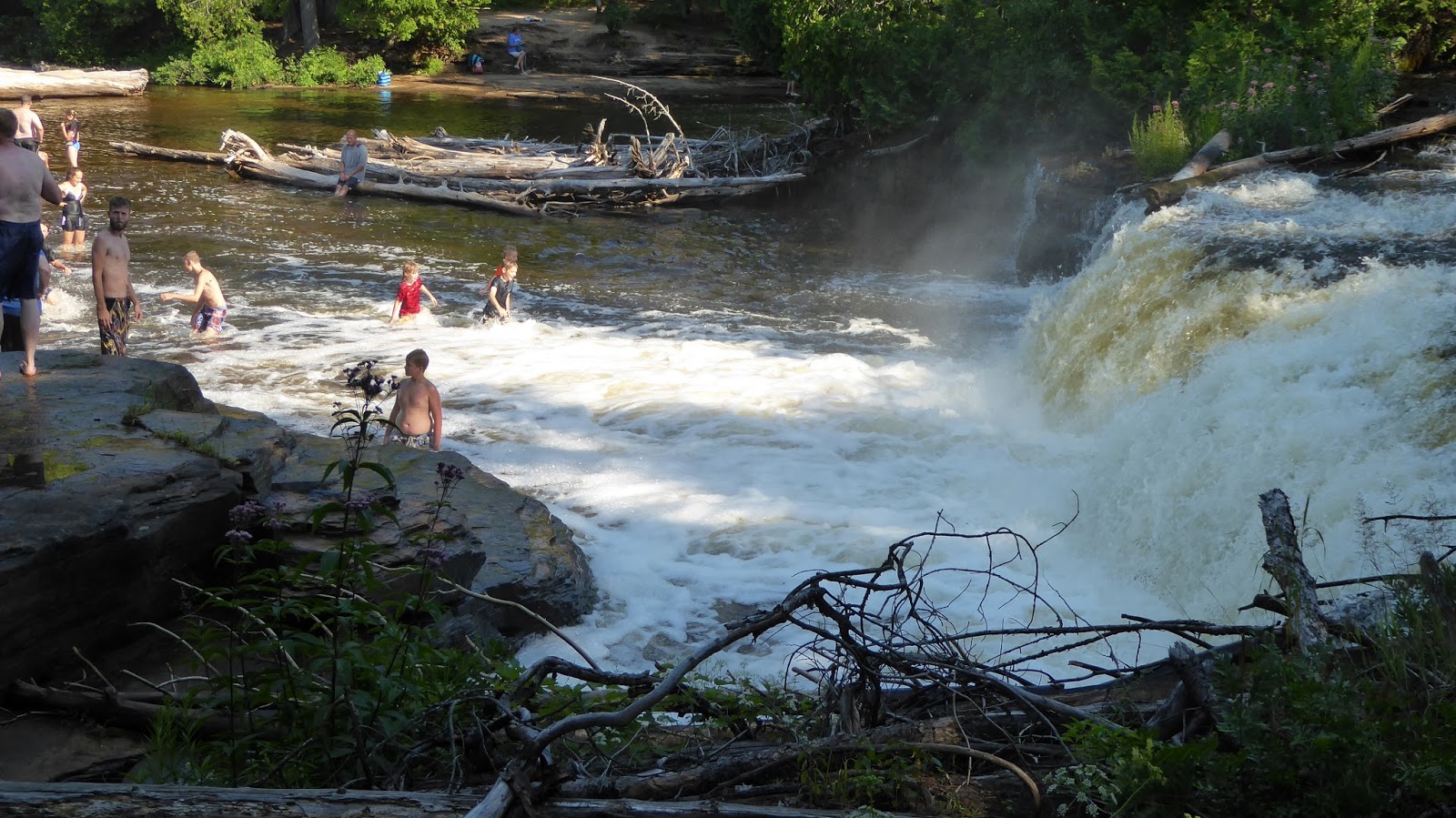


Joe kept getting deeper and deeper, but he managed to stay upright, although he was in some current.


In
the heart of the second largest Michigan state park, the 90 mile long
Tahquamenon River rushes over a 50 foot drop at the magnificent Upper
Tahquamenon Falls. Four miles downstream, a series of five smaller drops
make up the majestic Lower Tahquamenon Falls, carrying the river
farther downstream before emptying into Lake Superior at the rivermouth.
- See more at:
http://www.michigansparadise.com/tahquamenom-falls/#sthash.4hE5wxHL.dpuf
The
Upper Tahquamenon Falls is the second largest waterfall east of the
Mississippi River. - See more at:
http://www.michigansparadise.com/tahquamenom-falls/#sthash.4hE5wxHL.dpuf
In
the heart of the second largest Michigan state park, the 90 mile long
Tahquamenon River rushes over a 50 foot drop at the magnificent Upper
Tahquamenon Falls. Four miles downstream, a series of five smaller drops
make up the majestic Lower Tahquamenon Falls, carrying the river
farther downstream before emptying into Lake Superior at the rivermouth.
- See more at:
http://www.michigansparadise.com/tahquamenom-falls/#sthash.4hE5wxHL.dpuf
In the heart of the second largest Michigan state park, the 90 mile
long Tahquamenon River rushes over a 50 foot drop at the magnificent
Upper Tahquamenon Falls. Four miles downstream, a series of five smaller
drops make up the majestic Lower Tahquamenon Falls, carrying the river
farther downstream before emptying into Lake Superior at the rivermouth.
- See more at:
http://www.michigansparadise.com/tahquamenom-falls/#sthash.4hE5wxHL.dpuf
In
the heart of the second largest Michigan state park, the 90 mile long
Tahquamenon River rushes over a 50 foot drop at the magnificent Upper
Tahquamenon Falls. Four miles downstream, a series of five smaller drops
make up the majestic Lower Tahquamenon Falls, carrying the river
farther downstream before emptying into Lake Superior at the rivermouth.
- See more at:
http://www.michigansparadise.com/tahquamenom-falls/#sthash.4hE5wxHL.dpuf
Subscribe to:
Posts (Atom)