This morning was our day to leave the country and head into Canada. For some reason, ours was the only GPS that would show Canada, so Marilyn and Mazie will have to figure out why theirs won't when we get to camp tonight. Of course, the problem with that is that we won't be using our hotspots for internet, so we will have to go find wifi somewhere.
Both Collins and David wanted to top off their propane tanks, and Collins found a place yesterday where they sold propane, but the sign said they didn't open until 9:00 so we did not plan on an early start. And we all needed to top off our fuel tanks, assuming gas in Canada would be a lot higher. We left the campground about 9:30, but it was about 10:15 by the time we all got the fueling done. It was nice this morning, in the 60s, moving on up to the 70s by afternoon. As we neared the border crossing, we crossed the beautiful Niagara River.
We had to pay a $14.00 toll to cross the border. For some reason, the border guard decided our RV needed to be inspected, or searched, or whatever, so while our traveling companions were able to pull on through, we had to pull off and let the border patrol people (3) search our coach, while we were asked to step over to the building and wait outside. That process probably took about 20 minutes, but they finally returned our passports and sent us on our way. So we entered Ontario about 11:15.
We drove through a couple of towns, and followed Lucille right to our campground, outside of Niagara Falls, Ontario. We are right on the river, and Mazie and I walked over to it after we got set up. The campground is a little soggy from all the rain around here, but otherwise, it is a nice grassy, shady spot.
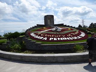
After we all had a sandwich for lunch, we headed to the Falls to get information for tomorrow. David opted out of this little trip, he had a headache and was going to lie down for a while. The road takes us right alongside the falls, but all of the information areas charged to park in them, usually $20. We finally stopped at a gift shop and got a little information, but not what we needed. So we went on our drive a way further, passing this beautiful Flower Clock that Collins had mentioned.
Then we found a fruit stand, but their prices were pretty high so we didn't buy anything, and Marilyn and Mazie only bought a little. It all looked good, though.
Strawberries were $32.00 a case (not sure what they called the "case", that's my word); cherries were $15 and $10 a basket, and apples were $6.99 a basket. All Canadian money, so it should be about 20% less in American dollars.
We drove into the town of Clifton Hills looking for a Visitor Center, but the one we found only had brochures, no person staffing a counter, so we still don't have the information we need for tomorrow. They sell an "Adventure Pass" here like on the U.S. side, for 4 attractions for $54.95. That includes the boat ride and a movie, which we aren't too interested in doing again, but we haven't found out what the other attractions cost as single tickets, "Just Behind the Falls" and the "White Water Walk." And, of course, there is the bus transportation to deal with.
We finally headed back to camp. We are thinking we will drive back to the Walmart to pick up a few things, and the M&M girls think they might need a mini SD card to get their Canadian information to come on their GPS, so I don't think we are in for the night yet. And I need to go find a wifi to get this posted.
Well, we weren't done with our day yet. We (the 5 of us, David stayed home again, smart guy) did, in fact, drive in to Walmart, then over next door to McDonalds to get on their wifi. But their wifi didn't work, so we ate, and wasted an hour there, then decided to find the local library. With Lucille's help, we did find it, and passed right by a large Visitor Center, the one we were supposed to find while ago. Apparently, we turned the wrong way, but we don't even know if we were on the right road when we turned. Oh well, we know where it is tomorrow.
We got to the library at 7:35, and it closes at 8:00. Mazie is rapidly downloading the Garmin updates, with Joe over her shoulder, Marilyn is at another table doing the same thing. I'm sure they will be running us out of here momentarily. They just announced the 10-minute warning, so I'm outa here!
Rain is predicted again for tomorrow, so we will have to wait and see what we accomplish tomorrow. We are here until Thursday, so we have a few options.
Monday, June 29, 2015
Sunday, June 28, 2015
Erie Canal (6/28/2015)
Although it rained all night, and I guess it stormed some (I didn't hear anything), we decided to go ahead with our plans to take the Erie Canal boat ride this morning. It was down to just a mist, so off we went. This is the sign we saw as we drove through town the other day, and got us interested in finding out about the Erie Canal.
We bought our tickets, then Joe and Collins were up to their usual antics.
Joe found a map on the wall that follows the path of the Eric Canal. "The Erie Canal is a canal in New York that originally ran about 363 miles from Albany, New York, on the Hudson River to Buffalo, New York, at Lake Erie. Built to create a navigable water route from New York City and the Atlantic Ocean to the Great Lakes, the canal helped New York eclipse Philadelphia as the largest city and port on the Eastern Seaboard of the United States. The canal is now part of the New York State Canal System." "The Erie Canal is famous in song and story. Proposed in 1808 and completed in 1825, the canal links the waters of Lake Erie in the west to the Hudson River in the east." This canal was dug by hand, 4 foot deep and 40 foot wide, later it was deepened to 12 feet to handle larger boats. The War of 1812 delayed the completion of it.
On a nicer day, this would be a very peaceful ride to cool off. Today, it was plenty of cool! Here, some of us are really concentrating, trying to absorb it all (Joe is the photographer). Our two fair-weather buddies, Marilyn and David, are staying inside, although Marilyn did venture up to the upper deck a little later.
Here is the lock, filling with water, which amazingly took very little time.
Gates closing.
Now we are full, and floating up.
Gates opening, then going under bridge upstream.
More pictures, then Joe the Photographer running over to join in.
Coming into the lock again, gates opening.
Inside lock.
Bridge rising just like an elevator to allow us to pass under it.
Joe saw a beaver in the canal along here, and there was a flock of geese on the edge. We finished this ride and deboarded the boat, then we all went our separate ways. Joe and I took a drive, of course, stopped for lunch, and came upon this very nice view up the highway, nearing Lake Ontario. Lake Ontario was completely socked in with fog.
But I did brave the elements and stick my toe in it. Great Lake Number Two! And we came upon a lighthouse.
We drove along the coast, even though we really couldn't see the water through the fog. This is a beautiful part of New York -- we don't think of New York having countryside, crops growing in fields. We passed several orchards, some peach, some apple, some cherry.
The peach trees are a long way from in-season, the apples were setting on and some of them turning red but we don't know what kind they are, and the cherries are ripe right now. We bought a lb. each of 2 different kinds. When we walked over to look at the apple trees, we scared up a red fox. So two animals today.
We wandered our way back, stopped and fueled the car, and got back to camp. Joe went passing our cherries to our buddies since we can't take them across the border. He intends to give himself a stomach ache by eating the rest of them tonight.
And tomorrow we are leaving the country -- we are going international, to Canada!
Pierce Arrow Museum (6/27/2015)
Our campground here in Lockport, NY is pretty nice, grassy, spaces are
wide, but they planted a tree in the middle of our spot so we couldn't
put our awning out, and the door actually hits the leaves when we come
out the door. After our rain today, Joe came out without his raincoat
and opened the door right into the tree, and got a drenching.
It rained a little during the night, but it wasn't raining when we got
moving. Dave and Mazie had plans to meet up with a friend who they knew
from when they were selling their Missouri property a few years ago, so
the other 4 Ruskateers headed off to Lockport to check out the Erie
Canal boat ride, which we are doing tomorrow. It started raining as we
got there, and it rained the rest of the day. But we all forged ahead,
our next stop was the Pierce-Arrow Museum in Buffalo. I'm sure Joe took
a picture of every car inside here, but somehow I deleted most of the
chip this morning, so I'll just post a few.
There were lots of other artifacts too, pedal cars (my kids had one of these), bicycles, and even a buffalo painted like Elvis.
Frank Lloyd Wright had designed a gas station for one of the gas companies here in Buffalo. It was very fancy and Write wanted $1750 for his design. The company only had a $1000 budget for the design, so it never got built then. It has been created inside this museum. The car here was one of Frank Lloyd Wright's car, but they had repainted it orange. The tour guide said he liked to drive around Phoenix in it, but it was bright red then.
Somehow I accidentally deleted the rest of the pictures from yesterday's camera chip (I didn't even get the Elvis buffalo, but I went online and found a picture of that).
But we did go on to another museum after a very nice lunch at Chef's (it was graduation day in Buffalo so we got to see lots of kids all dressed up in fancy dresses and white shirts and ties).
Our next stop was the Theodore Roosevelt Inaugural Historic Site, which was a guided tour of the house where Teddy Roosevelt took the oath of office after President McKinley's death. (lost all of these pictures)
After we finished here, we drove around Buffalo a little, checked out the harbor but it was raining too much to enjoy it. There was a naval & military park here and possible a navy ship we could have toured, but the weather did not cooperate.
We were so lucky to have had such a beautiful day yesterday to see Niagara Falls. Today it rained all day, was gray and wet and cool -- an unusual day for us Arizonans. We've had our bedroom window open the last couple of nights, with the fan on. But tonight, we had the furnace on, and it's supposed to only be in the 50s tomorrow.
Subscribe to:
Posts (Atom)