Lynx
Wolves
Black bears
The bobcat wouldn't cooperate for a picture, and the grizzly bears were "off exhibit."
The walk took us through lots of trees, which they had identified, a nice feature. So I took a picture of the red alder sign that I missed the other day.
Then we got on the tram, it was a 50-minute ride and we got to see lots of hooved animals, some of them up close. They were not spooked by the tram at all.
Caribou
Big horn sheep
Mountain goat
Buffalo with baby


Moose
Elk cooling off in pond

Caribou again, leading the tram back to the station.
We drove on to Mt. Rainier National Park to begin our tour of the mountain, passing the beautiful Nisqually River along the way, and entering the park through the Nisqually entrance about 1:00. "Mt. Rainier is the center of the nation's fifth national park, 14,410 feet tall, it is the tallest volcano in the Cascade Mountain Range and the most glaciated peak in the continental U.S. Glaciers, massive rivers of ice up to 750 deep, flow down the rocky slopes. Yet, on the summit, steam escapes from deep within the mountain's core" (we didn't see the steam)>
We are surrounded by forests and this was a pretty drive, though curvy and up/down the mountains.
We took in a few waterfalls along the way, some right by the road, some involving short hikes and steps.
Christine Falls
We got to the visitor center at Paradise Inn, had lunch there, and continued on. We never did see the valley of wildflowers that was supposed to be around here.
We got some pictures of the mountain here but the clouds were still hiding the top.
We stopped at another lookout to get a picture of the jagged mountains to the south and I suddenly realized I was standing in sunlight. The mountain is beginning to peek out, but the clouds are still in the way. There was a couple here with a scope aimed at the mountain, and they showed us where the mountain climbers were, way up near the top on one side.
Our Buick made the blog.
The tiny dots above are the hikers. We could also see a waterfall at the top, and a glacier.
At the next stop, we were level with the snow.
This waterfall was a bit of a hike, and we didn't take it all the way to Myrtle Falls, lots of steps, but we gave it a valiant effort. I think it was a mile hike AFTER we got to the Skyline trail. I finally persuaded Joe to give it up, and we headed back down.
We could see the hikers from here too.
As we wound our way around the hills and down the mountains, Mt. Rainier finally popped out!
Then I exhausted my second camera battery, so I had to switch to my phone. We missed one falls along the way, but we did stop at Reflection Lakes. However, the sun was not at the right angle for the reflection, but it was still a pretty lake. We drove through Stevens Canyon, to Martha Falls, crossed Backbone Ridge, and our final stop and hike was at the Grove of the Patriarchs. I had a hard time getting my phone pictures to download, and then I couldn't find them when they finally did, but I think I am now ready to finish this blog. The rest of these pictures are off my iPhone.
This turned out to be probably a mile hike each way, and we were pretty tired by now, but there was no way Joe was going to miss seeing these big trees. So off we went. I had my binoculars hanging around my neck and didn't think to take them off, which turned out to be a mistake. And Joe didn't put on his backpack and we didn't think to grab any water. Obviously, it was time to be done for the day.
We had to cross a swinging bridge to get to the Grove, so I finally put my feet in the water. This was the Ohanapecosh River.
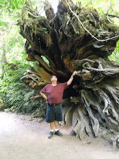
These tree roots were amazing. There were lots and lots of huge trees here, many were dead but a lot were still alive and standing tall.
Several of the downed trees act as "nurse trees" and become the parent of other young trees that take root in their bark.You can see 3 trees that are growing out of this "nurse tree."
There was a boardwalk around the Grove, which made it nice.
And there was a sign to the Big Cedar, which was helpful.

So we finally began our return part of the hike. Along the way we spotted a banana slug and a frog on our pathway. But those photos are on Joe's phone and I'm not up to another phone download. But just before we got back, the strap on my binoculars came undone, my binoculars hit the path, and two little plastic pieces broke off. Right after this happened, we heard a siren, and Joe said, "someone called the binocular amblance." Joe glued the two pieces back on this morning, so I think I'm back in business.
We walked over 12,000 steps today. We came out of the park at the Stevens Canyon Entrance, so we only got about half of it covered, but we got to see the mountain in full sun, so we accomplished that. The Sunrise area has a glondola ride but it closes at 4:00 and we were not anywhere near that by 4:00.
The first sign we saw after we got out of the park said our freeway was 84 miles away, plus we had another 20 miles on top of that before we got to the campground. That was discouraging. We finally stopped for Mexican dinner at the town of Morton, and got back to the campground about 9:15, a very, very long day!


