
Tuesday, July 2, 2024
West Side of Glacier National Park
We headed out this morning to the west entrance to the park. We got backed up at the entrance gate in a line, but it only took us about 15 minutes to get through. We entered the park at five minutes till noon. The Apgar visitor center was jampacked. There was a line there to get to the information desk, like at the movie theater, so we just looked at the map again and skipped the information desk. We took the Camas Road to what we thought was the Inside North Fork Road, but we later found out we were on the Outer North Fork Road. It runs along the Flathead River, and we left payment after about 10 miles and were on a dirt road. Joe was in his element. Snow-covered mountains are still around us to the east, but they are more distant. Our GPS tells us what direction we’re going and it’s usually a surprise, especially to Joe, which is a little scary.
A little restaurant popped up along this road - Home Ranch Bottoms. It was pretty rustic so we stopped. Hamburgers were $20 each so we left. I guess we were not hungry enough to pay that much for a hamburger. They advertise free music all day on the weekend so it is probably a happening place.

As we got back out on the road, there was a sign "wildlife crossing, next 3 miles" so we got our hopes up. In just a few feet, a chipmunk or prairie dog ran across the road. We saw probably a dozen of these and never did figure out if which they were, or even if they were all the same. I guess that qualified as wildlife.
There’s a long stretch on this road -- 20 or 30 miles -- that’s private property. It has residences, but also some businesses including the restaurant that we stopped at, plus a couple places with cabins for rent. They had a gas pump that doesn't look like it had worked in years, but the gas tank was colorfully decorated with stickers.

We finally got to the Polebridge Loop and turned onto this road. Traffic was backed up from the Mercantile at the end of the road. A road construction person came out and asked if we were stopping at the mercantile and we said no, so she directed us on past all the cars waiting in line and we took the left and got out of "town" if that was a town. There was road construction right on the edge of the town, but the Mercantile seemed to be doing a pretty booming business and there was little parking. People were parking their vehicles along the road and walking up to the store. We assumed they would have $20 hamburgers too, so we did not even go in.


The first part of this road was in pretty bad shape. Maybe that’s why they’ re doing the road construction. We met a couple hiking on this road, then a few feet behind him, another hiker, a single guy, was brushing his teeth with a battery-operated toothbrush as he walked. Guess he overslept.
All of these lakes and rivers, of which there are many, are beautiful. The water is a clear, emerald color, and usually they are moving fast, lots of white water tumbling over rocks. This is Bowman Lake.
We came up on the entrance to the park to find out that we had been on the Outside North Fork Road this whole time instead of the Inside North Fork Road, which is closed. But to the continue on to Kintla Lake at the end of the road we are on (our goal today), we had to have a reservation to return. We had not understand that, and had not made one so we could not continue. It was 1:30, and our options were to wait an hour and a half until the reservation requirement ended at 3 o’clock, or we could turn around -- so we turned around.
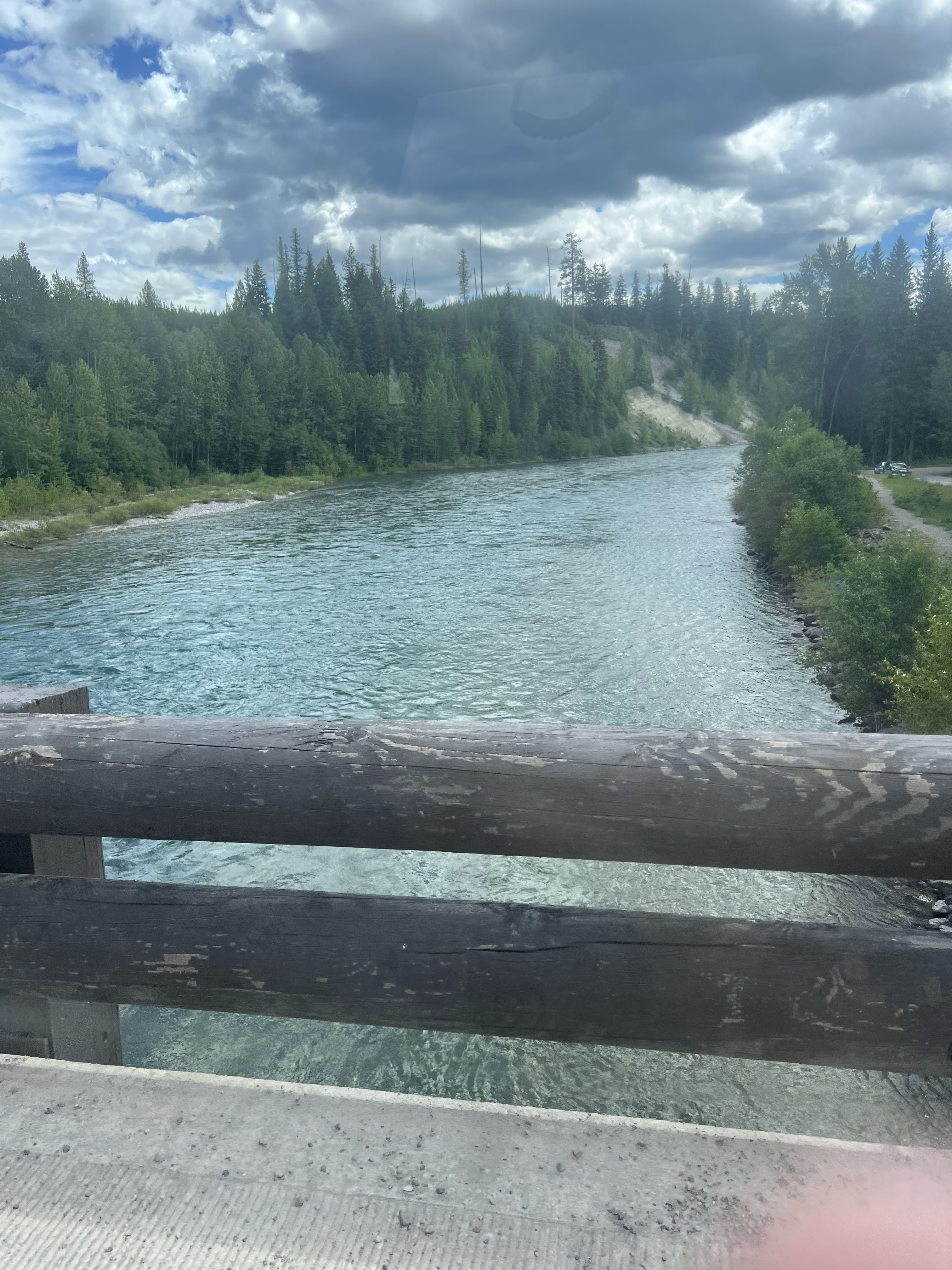
We turned around and crossed the bridge again. We could see a few people sitting down on the bank of the river. One of them looked like a naked girl, which Joe spotted. I only caught a glimpse. So, of course, we drove down to the river. Just as we got there, that little group went off on the trail underneath the bridge. Perhaps they were filming Naked and Afraid, but I didn’t see the film crew.

It was a lucky stop here because when I got out, my keys were hanging in the lock. I guess when we stopped at that lodge and filled up our soda cup out of our cooler, I left my keys in the keyhole. Disaster averted! So we went back through the construction to Polebridge to figure out our options. It was only a couple of miles back to Polebridge. We did have to wait for the construction this time, probably 10 minutes maybe
From Polebridge, we’re 22 miles from the Canadian border, but that border crossing is closed so we turned around and just headed back south. When we came back through Polebridge, traffic was lined up even further back, almost to the turn off. A lot of the cars were just parked along that road and people were walking up to the Mercantile.
We drove a few miles, and Joe saw a turnoff, so we took Haycreek Road, we thought it was a loop road. The road was pretty bumpy. They use conveyor belt strips in the ruts to try to stop the road from washing out, but that just added more bumps.

The side roads Joe chooses always have an element of surprise to them because we don’t know if they’re going come out someplace, or if we’re going to be turning around and going back the whole distance, or if they come out in Canada or Idaho or Yellowstone.

The GPS now says Hay Source ahead, which is a bit worrisome. I’m thinking we’re just going to end up at a hayfield, but I have a mountain on my side and a cliff on Joe's side so I really don’t see a hayfield coming up. It also says we are going west, which was a total surprise. We never did find the Hay Source.
We came up on a hiker sitting along the side of the road. We stopped to make sure she was all right. She said her feet were hurting and she was just taking a rest. We told her we would probably be coming back through shortly so we would check in and for her to flag us down if she needed anything. Just past her, there was a split in the road and sign that said "road slump ahead, trailers not recommended." I strongly suggested we turn around. Of course, Joe decided we should go check it out. Then it started raining which fortunately only lasted a few seconds that time.


Joe is so proud of his Jeep, and it's doing a wonderful job for us.

There were not many places along this road with enough room to pitch a tent.
So we made a note of our mileage when we turned around so we could tell the hiker. (56.8 at slump at 2:35 turn around). And I took a picture of a possible campsite where she could put up her tent. We were about 2 miles past her.

We did turn around at the slump, which was really a rock slide. (I'm sure Joe was considering whether or not to attempt that.) We came back upon our hiker, whose trail name is Mary Badass, just getting up from where she had been sitting when we went past. We fed her some cookies and pretzels and gave her what information we had gleaned from the two miles ahead. I showed her the picture of a little clearing at the slump that I thought she might be able to put her tent up on. She thought that might work for her but she’s looking for a water source. Joe told her there was a small trickle coming down the mountain and she thought that might work. I offered her some bottles of water, but she did not want to add to her load of carrying.

She’s a very interesting 67-year-old lady who is hiking all the National Scenic Trails. This is her ninth one, she gave me her phone number and I’m going to link her to my blog and she will link me to hers when she reaches her next stop. She hiked the Pacific Crest Trail in 1986. This hiking trip started in New Mexico, then through Arizona. She did the Arizona Scenic Trail, and then drove to East Glacier. From here she is hiking to the Washington coast. She’s on day six of this trail, 50 miles in, and she said she had 1200 to go. Her car is parked at East Glacier and she said she will probably take a train back from the Washington coast
By the time we got off of this little jaunt, which was 9 miles each way, it was after 3:00 so we decided to go back to Polebridge to complete our initial mission for the day. We got back in line for Polebridge at 3:15. The line is still backed up almost to the turn off. Parking is at a premium back here, partly because of the road construction so I assume that’s why the traffic is so backed up. When we came through while ago the left side of the road was lined with parked vehicles and the people had walked up to the Mercantile. But this time, after only about five minutes, they started letting everyone through to the turnoff, where we had to wait again for the road construction backup. And now it’s raining -- it had stopped raining after just a few drops when we were on the Haystack Road but now it looks like it’s a little more in earnest about it. We came upon a road grader parked. Joe yelled at him to put the blade down do a little work, but he didn’t seem interested. So at 3:30 we entered the park again, this time not needing a reservation.
We took the side road to Bowman Lake, which is 6 miles -- 6 awful miles. Joe said this is the worst road we’ve been on all day and we’ve been on some rough ones. Six miles of potholes each way and they are often completely across the road so there’s no dodging them. It really wears a person out there. Shockingly, there is a campground back here -- several people in it. There’s a 21 foot vehicle-length limit, so nothing big. Mostly trucks, SUVs and Class Bs. Several tent campers. And the bugs were terrible. But the lake was picture perfect.


The water in the lake was so clear you could see a few feet out. And I'm sure some of those rocks are worth collecting.

We really enjoy watching all these creeks and rivers, tumbling past -- they all seem to be in a hurry to get someplace
Joe hasn’t had much time to watch for wildlife today. He’s too busy watching for potholes. We did see evidence of an antler rub on a tree -- elk deer, moose?? The next rub we saw was right next to the road Joe said that was a jeep rub.

Bowman Lake was beautiful with a mountain backdrop, but we’re not sure it was worth the drive. Every vehicle I saw in the parking lot was from a different state. The campground looked nice and there were several vehicles back here, but the road through the campground was as full of potholes as the road getting back to it. On the way back out, it had quit raining, but now all the potholes are full of water and with the sun dappling through the trees, it’s almost impossible to see them in time to dodge them. It took a half- hour to drive the 6 miles back out, 30 miserable minutes each way. The first and last mile had recently been graded so that was a little better. I sure hope they go back and finish the job because the rest of it was practically impassible. I spent most of this drive hanging onto the grab handle -- thank you Jeff and Brenda.

Back to the main road, we continued on to the end at Kintla Lake. This was a much better road. Toward the end of it, we came to Big Prairie and Round Prairie on both sides. This area certainly looks like it would be good for grazing wildlife but we’re probably a little early. It’s only 5 o’clock.

We continued on this road for another 45 minutes to where it ends at Kentla Lake. Joe kept complaining that he thought it continued on because we weren’t seeing any traffic coming out, but finally within the last 2 miles we did meet a car, so I told him that meant that it was not a loop road. They had told us at the park entrance that we had to come back out the same way, but he just kept thinking there had to be another way out. This is the Inside North Fork Rd., the only part of it we got to drive and which is only available to us from Polebridge. We spent 45 minutes driving back to this lake and about 10 minutes here, and then we headed back out. There is a campground back here, very similar to the one at Bowman Lake. There were a very few vehicles back here, a family sitting on a picnic table down by the lake, and a guy in a kayak pushing off. The view here is stunning -- mountains, clear water -- some people will never see anything this beautiful in their entire life. But you have to work to get here. No wildlife at this point except probably a dozen prairie dogs, chipmunks or something about that size — nothing taller than 6 inches. We passed a "moose looking" pond, but there was no moose, and a beaver dam, but again, no beaver.
We are now at the end of today’s drive -- right at 100 miles, so we’ve turned around and are heading back. Don’t know if we will have to go the whole 100 miles or if we can find a shortcut. It’s now 5:45, a good wildlife viewing time, so we have high hopes.
Heading back, we’re a little hungry. We missed lunch so we’ve been snacking on everything in the jeep -- cheese sticks, half a bag of pretzels, two cookies before we gave the other two away to Mary Badass, Joe had some sausages, I had more pretzels, a couple pieces of taffy and some hot tamales, so we haven’t starved, but we’re ready for some real food.
Shortly after we turned around, we may be gone two or 3 miles, a pick up coming at us stopped us and asked if there was a lake back here. We told him he was only 2 or 3 miles out. He thought he might be in Canada. We shared the same thoughts on our way in.
Every time we stop and get out, the bugs just swarm the jeep and since we aren’t exactly fast at exiting, we usually get some inside. Joe became obsessed with them after our stop at the lake because he thought he got bitten. All of a sudden, he yells "skeeter" and starts banging his hand on the window. I yelled "tree" which was looming right in my windshield. We missed the tree. I don’t know if he missed the mosquito too or not (he did).
About 6:30 we saw our first (and only) deer. Joe actually thought he spotted one about a mile back, but he didn’t get a good enough look to know for sure, but this one cooperated. I didn't see the first one.

Joe had spotted a beaver dam on our way to the end of this road, so on the way back, we stopped and got a picture.
6:50 now. We were probably about 7 miles from the Canadian border when we turneded around at Kentla Lake. But there is no border crossing in this area. I think the closest one is Roosevelt.
We spent eight hours in the Jeep. We got out of the park and drove past the camper to Whitefish to get something to eat. It’s now 8 o’clock. We’re hungry and we’re tired. About all we could find in Whitefish was either "fine dining" or bar and grill so we ended up at McDonald’s. At least we didn’t have to spend $20 for a hamburger here. Back in the RV at 8:40. 166 miles today, so obviously we found a shortcut on the way back. Joe said it was probably 60 miles of pavement and 100 miles of dirt road -- long day.
But our day wasn't quite over. We watched the Diamondbacks game, then two episodes of a show we have been following on Prime TV. It had rained again, and Joe thought he should probably bring in the awning. He read that the Northern Lights might be visible here tonight, and that might interfere with out viewing. But he didn't get up and do it then, so when I reminded him 2 hours later, he stood in the doorway and watched it retract. When it got all the way in, it dumped a bunch of water on him. I laughed, but he was not a happy camper, and it was 1:00 a.m.

Today was a long, hard day so tomorrow we will probably take it easy. Time to do laundry, and maybe some housecleaning. And we need to figure out what's going on around us on the 4th of July. We basically have completed our goals for West Glacier so we are not sure what else we will do here. We leave on Sunday, but don't know where we are going. Oh, retirement!
So do RVers have trail names? With all the gravel trails you explore… 😎 -Cathy
ReplyDeleteI haven't heard any. But the RVs and Jeeps might.
ReplyDelete