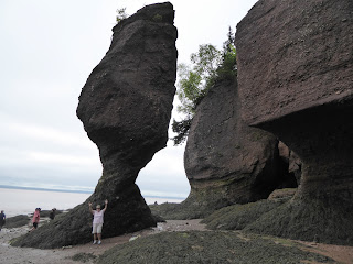
The second thing was Hopewell Rocks and the Bay of Fundy. As I said earlier, this is a bucket list item for Joe, ever since Collins told him about it after their trip here in 2009. And it lived up to its claims.
We got there around 10:00 and made the 15-20 walk down the trail to the steps which take you down to the ocean floor. Low tide was at 10:51 a.m., so we had a little time to watch it still receding, before it started coming back in. It was quite amazing, and of course we got lots of pictures. And I found one piece of seaglass -- a clear piece this time.
Here's some of the photos -- we took a ton, but this one rock formation you will see again as we time the tide coming back in.
There were the usual steps -- someone counted 93. Joe went up and down these 3 times, but I only made one extra trip halfway down and back.
There were beautiful rock formations "carved by melting glaciers and then sculpted by the World's Highest Tides."
Some of the rock formations are known as the "flowerpot rocks," which are the ones on brochures. "The amount of water flowing into the Bay of Fundy during 1 tide cycle is eual to the outflow of all freshwater rivers in the world combined."
 |
| Flowerpot Rocks |
One of the park rangers was industrially busy building a cairn of balance rocks and sticks, which would be taken down as soon as the tide reached it. But he showed a lot of talent in his balancing act.
This is called the chocolate river, the "effect results from the silt from the mudflats being stirred by the constant movement of waters." Where there wasn't rock, there was mud. We saw one lady, and one little kid get their shoes stuck in the mud. Joe took a picture of the dad trying to retrieve the kid's shoe, but they weren't real sure where it was in the mud.
And I got to put my toes in the Bay of Fundy!
We hit low tide and walked around a bit.
Then we took a break about 12:30 and took the shuttle back to the visitor center and restaurant, where we killed an hour eating a leisurely lunch and resting. Then we went out to the car and got our books, took the shuttle back down to the viewing platform, and just hung out until high tide at 4:35. We would both get up occasionally to check the changes in the water coming in across the ocean floor. Joe started taking photos of the ocean floor and the clock to show the drastic change in just a half hour's time. Low tide was 7.9 feet, and high tide was 37.7 feet, a 30-foot difference in just about 6 hours. It will be even higher later this month, at 39.1 on the 26th.
Kayakers are now floating under the rocks we walked under just a couple of hours earlier.
By high tide, there was just a few inches of ground left above-water. Joe went down again before it got all the way up and took a selfie, then traded picture-taking chores with some lady. She jumped in her photo, so when she took a picture of Joe, she told him to jump too.
 |
| JOE CATCHING SOME AIR!!! |
At High Tide, a couple of the park rangers had a little "ceremony" to celebrate the moon and the sun, giving credit for both for the tides.
After this event was over, Joe made one last trip down the stairs to absorb the full effect of this phenomonen. This is when I walked halfway down to take his picture at the bottom of the steps, which were now underwater.
Completing the cycle, we headed back into Moncton, stopping off at the Visitors Center to get information about the bore tide, which is right next door to it. We will probably stay over and go back in for that tomorrow.
We got back to camp just before Collins and Marilyn returned from their birthday seafood dinner. After catching up a bit and discussing travel options for the next few days, we had a sandwich, then went over and shared birthday cake with them. I was really tired for walking all over the ocean floor, so we called it an early night.
Joe tried out a couple of spots in the RV to hang his lobster buoy, but nothing quit fits. I'm pretty sure hanging it in this spot will hit me on the head every time I'm at the sink.
We will have to work on this.


No comments:
Post a Comment